
Geographic Setting of Our Archaeological Site
![Credit: Elise Laugier [2]](https://images.squarespace-cdn.com/content/v1/5632050ae4b0af803f470c20/1447876836368-FYCESF4V3JPZWAHG5G7K/image-asset.jpeg)
Credit: Elise Laugier [2]
By Adam Miglio and Elise Laugier
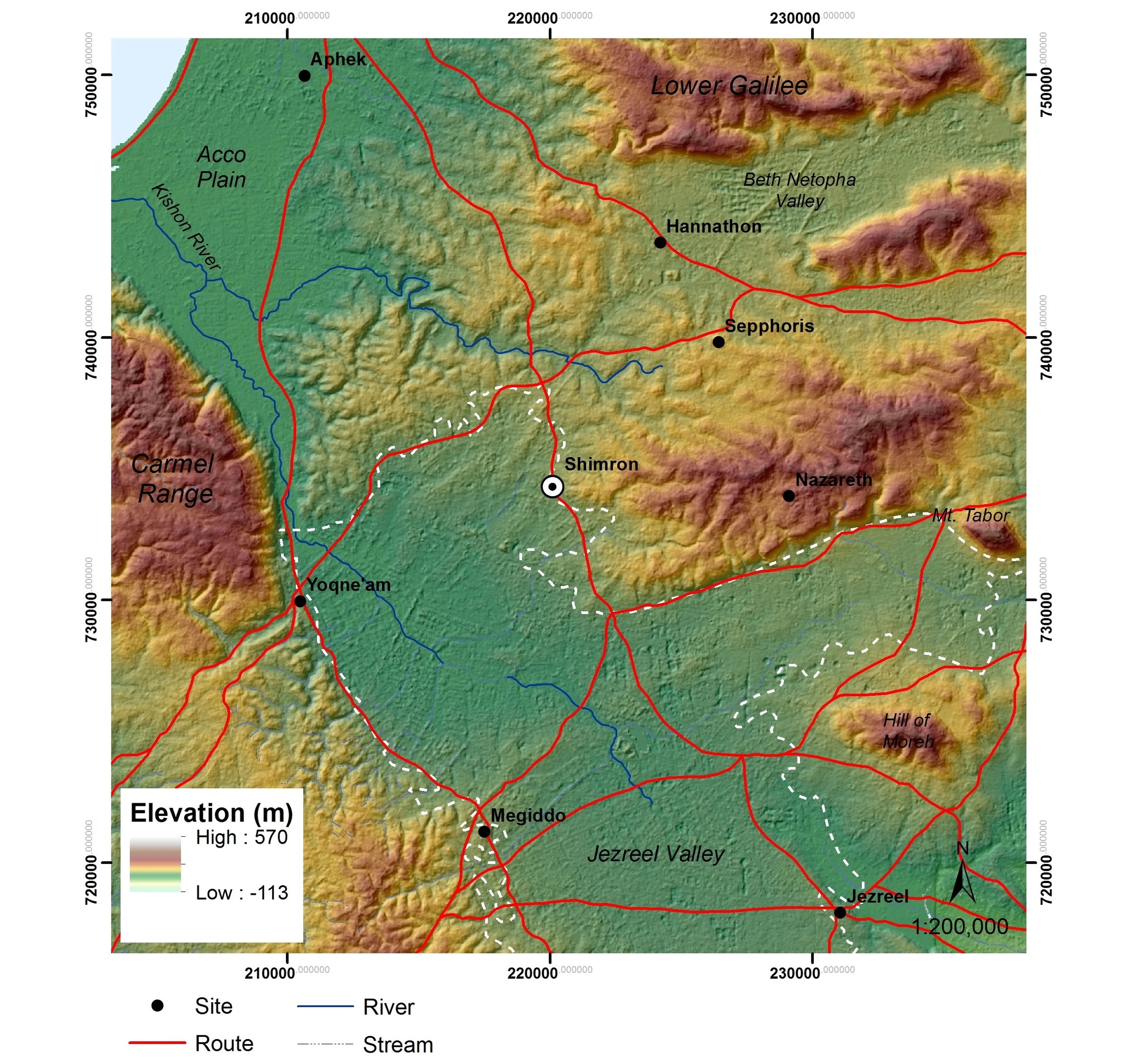
Tel Shimron lies at the northwestern edge of the Jezreel Valley. The acropolis at the site is situated at the east edge of the Tel and rises nearly 60m above the lowest portions of the settlement along the western edge of the site. At its largest, during the Middle Bronze Age (MB), Tel Shimron expanded to roughly 19.5 hectares (Raban 1982; Portugali 1982), and preliminary surveys have identified remains spanning from the Neolithic through the Ottoman periods (Raban 1982; Portugali 1982; Feig 2007, 2009).[1]
Credit: Elise Laugier; ASTER DEM courtesy USGS
The earliest historical mention of the ancient city at Tel Shimron comes from a Middle Kingdom Egyptian source. Throughout the MB as well as during the Late Bronze Age (LB) the city was known as Šamʕôna. It may be that during the Iron Age (IA) the city came to be called Šimron, only to be later Hellenized in the form Simōnias and to appear in Arabic as Seimûniyeh (Rainey 1976).
Credit: Elise Laugier; ASTER DEM courtesy USGS
Credit: Elise Laugier; ASTER DEM courtesy USGS
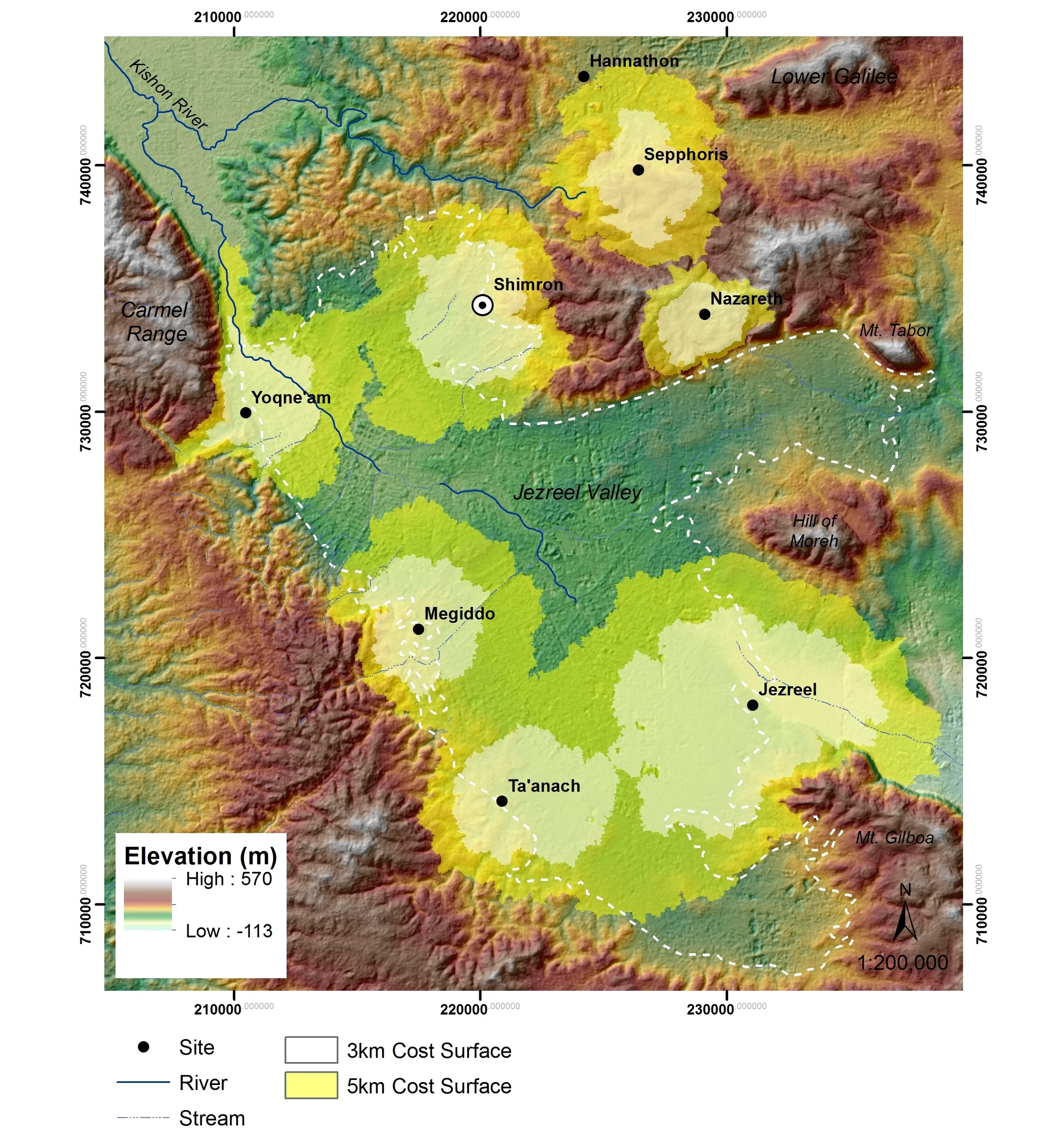
The history of the Jezreel Valley is inextricably intertwined with the ranges of lower Galilee. The relationship between these regions varied over time, as is witnessed by the oscillating settlement patterns in the adjacent hill country (Zori 1977; Raban 1982; Gal 1980, 1981, 1992). Tel Shimron is a nexus between these two regions, being situated in the Jezreel Valley and along the limestone and chalk gradients of the western lower Galilee. Geologically, the hills of the lower Galilee protrude southward into the valley just to the east of Tel Shimron. And to the west, too, low rolling hills cradle a portion of the Jezreel Valley, separating it from the plain of Acco and creating the Shimron alveolus that is discrete within the Jezreel Valley.
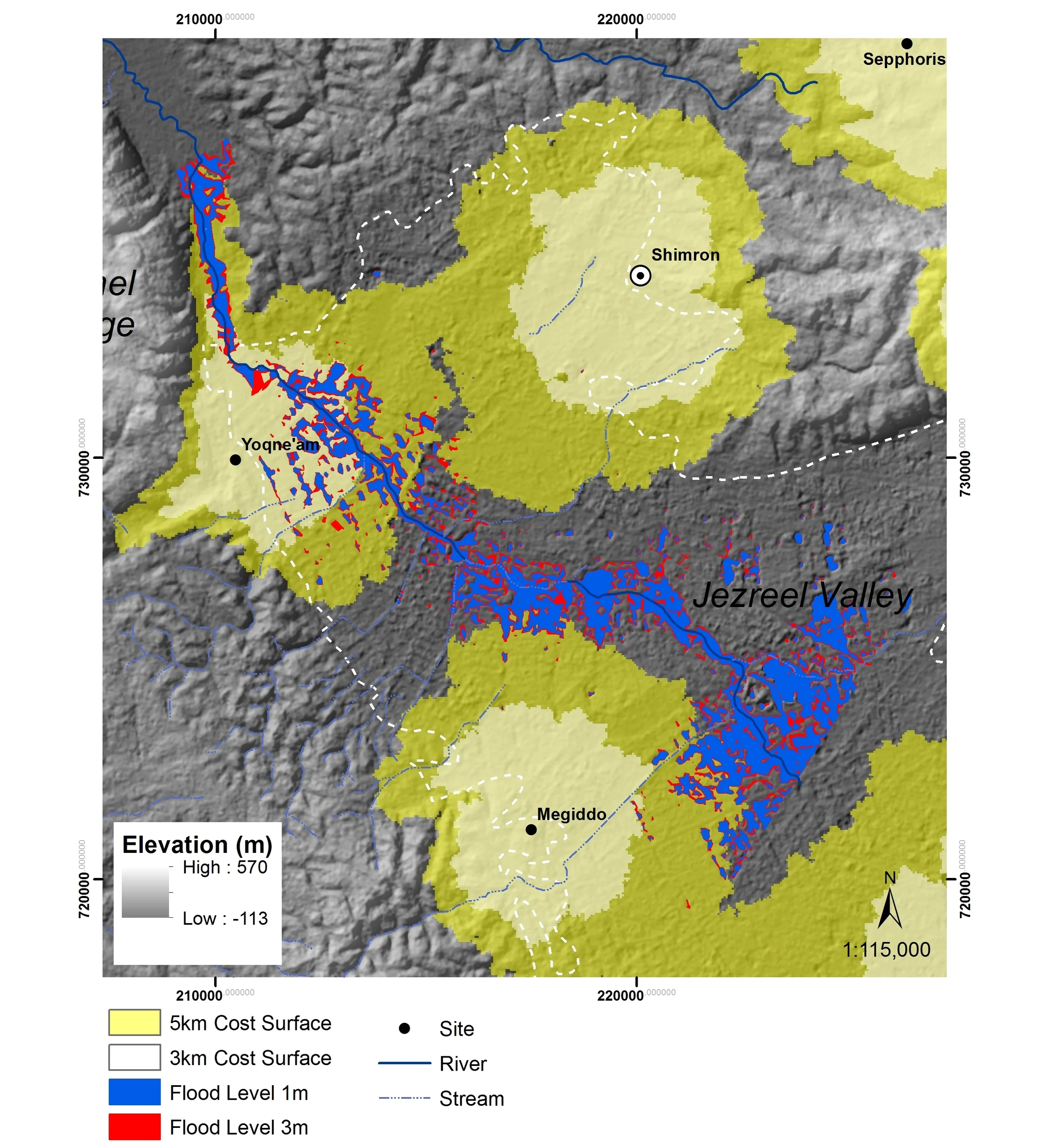
Tel Shimron rises above this alveolus that provided the site with rich and fertile lands for agricultural production throughout the history of the region. Specifically, Shimron’s nestled positon in the valley translates to a comparatively large, well-drained agricultural catchment, or sustaining, area (Vita-Finzi and Higgs 1970; Wheatley and Gillings 2002; Wilkinson 2003; 2005) - which may indicate its regional competitiveness, if not prominence, in terms of agricultural yield and thus population support (Wilkinson 1994). In fact, Tel Shimron’s catchment is far less susceptible to local flooding conditions than are its close competitors.[2]
The prominence of Tel Shimron within the Jezreel Valley made it an integral part of the transportation routes and political networks that crisscross the region (Smith 2003). Tel Shimron is situated along branches of the coastal highway that transect the Jezreel Valley from the south (Megiddo) and southwest (Yoqne’am). These trails that lead across the valley converge and pass by Tel Shimron en route to the Beth Netopha Valley (Hannthon/Asochis/Shiḥin) and to the upper Galilee. At the same time, east-west routes stretch to and from the Rift Valley and even more closely connect the site with the plain of Acco. Tel Shimron overlooks the east-west conduits proximate route leading from Tel Shimron to the plain of Acco passes through the hills to the northwest of the site, along the along the road to the Beth Netopha Valley. And to the south of Tel Shimron, the Kishon pass at the southwestern end of the valley provided an alternate outlet from the Jezreel to the coastal plain (Monson and Lancaster 2008).
[1] This does not account for the role that pastoralism would have played in subsistence (Zeder 2003; Porter 2004).
[2] Lidar imagery courtesy of Jezreel Valley Regional Project; map projections composed by Elise Laugier
Bibliography
Feig, N. 2007. "Tel Shimron." Hadashot Arkheologiyot – Excavations and Surveys in Israel. 119.
______2009. "Tel Shimron." Hadashot Arkheologiyot – Excavations and Surveys in Israel. 121.
Gal, Zvi. 1980. Ramat Issachar: Ancient Settlements in a Peripheral Region. Tel Aviv: Hakkibbutz Hammeʾuḥad. [Hebrew]
______ 1981. Tel Rekhesh and Tel Qarney Ḥiṭṭin. Eretz-Israel 15, 213-221. [Hebrew]
______ 1992. Lower Galilee During the Iron Age. American Schools of Oriental Studies Dissertation Series 8. Winona Lake, IN: Eisenbrauns.
Monson, James, and Steven Lancaster. 2008. Geobasics in the Land of the Bible. Rockford, IL: Biblical Backgrounds, Inc.
Portugali, Yuval. 1982. “A Field Methodology for Regional Archaeology (The Jezreel Valley Survey, 1981).” Tel Aviv 9/2: 170–88.
Raban, Avner. 1982 Archaeological Survey of Israel: Nahalal Map (28) 16–23. Jerusalem: Archaeological Survey of Israel.
Rainey, Anson. 1976. “Toponymic Problems (cont.).” Tel Aviv 3: 57–69.
Smith, Adam T. 2003. The Political Landscape: Constellations of Authority in Early Complex Polities. Berkeley: University of California Press.
Vita-Finzi, Claudio, and Eric Sidney Higgs. 1970. “Prehistoric Economy in the Mount Carmel Area of Palestine: Site Catchment Analysis.” Proceedings of the Prehistoric Society, 36:1–37.
Wheatley, David, and Mark Gillings. 2002. Spatial Technology and Archaeology: The Archaeological Applications of GIS. London: Taylor and Francis.
Wilkinson, T. J. 1994. “The Structure and Dynamics of Dry-Farming States in Upper Mesopotamia.” Current Anthropology 35 (5): 483–520.
______ 2003. Archaeological Landscapes of the Near East. Tucson: University of Arizona Press.
______ 2005. “Approaches to Modelling Archaeological Site Territories in the Near East.” In Non-Linear Models for Archaeology and Anthropology: Continuing the Revolution, edited by C.S. Beekman and W.W. Baden, 123–38. Aldershot: Ashgate Press.
Zori, N. 1977. The Land of Issachar: An Archaeological Survey. Jerusalem: Israel Exploration Society. [Hebrew]